Washington Back Country Discovery Route
 08-27-2012, 08:55 PM
#71
JK Enthusiast
Thread Starter
Join Date: Nov 2008
Location: Seattle, Washington
Posts: 312
Likes: 0
Received 0 Likes
on
0 Posts
I hate to say it ladies and gents, but I'm no longer able to join in this trip. Fell on some tuff times recently, and my money is needed elsewhere. My Jeep's upgrades have to wait yet again, as do any trailing/wheeling.
PLEASE PLEASE PLEASE takes tons of pictures and videos so that I can live vicariously through all of you
keep me posted on what you guys decide/do!
PLEASE PLEASE PLEASE takes tons of pictures and videos so that I can live vicariously through all of you
keep me posted on what you guys decide/do!
 05-26-2016, 07:26 AM
#72
JK Enthusiast
Join Date: Jun 2014
Location: Tumwater, Washington
Posts: 132
Likes: 0
Received 0 Likes
on
0 Posts
Anyone done the WABDR yet this year? I know its early so some areas may still be un-accessible. Any trips planned for later this year? I am looking at doing the south to north run most likely in early August.
05-26-2016, 11:13 AM
#73
JK Enthusiast

We did section 1 this week end from Bridge of the Gods to Packwood. A bit of snow at 4k ft but not too bad. There were a lot of downed trees that we took care of for you though. 
https://www.youtube.com/watch?v=j7RNjJxjv3Y
https://www.youtube.com/watch?v=j7RNjJxjv3Y
06-03-2016, 06:56 AM
#74
JK Enthusiast


My son did Section 4, from Wenatchee to Lake Chelan. Ran into a difficult snow bank on Slide Ridge, just south of, and thousands of feet above, Lake Chelan. Also did some sawing and winching to clear downed trees. But that section is open - just watch the snow drift...
Looks like most of the area called "the jungle" - the tightest, most challenging part of the WABDR - burned very badly last year. From what I could see, most of it was burned down to bare earth. Sadly.
CW
06-14-2016, 06:32 PM
#75
JK Enthusiast
Join Date: Jun 2014
Location: Tumwater, Washington
Posts: 132
Likes: 0
Received 0 Likes
on
0 Posts
I went west from Yakima today on highway 12 up and over white pass gazing longingly at the turn offs onto the WABDR. There were some snow flurries up at the top of the pass and snow visible just above the ski resort. Really looking forward to making this trip later this summer.
08-30-2016, 07:53 AM
#77
JK Enthusiast
Join Date: Jun 2014
Location: Tumwater, Washington
Posts: 132
Likes: 0
Received 0 Likes
on
0 Posts
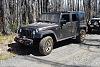
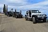
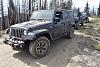
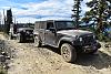
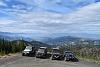
Got out on the route this weekend and did Leg 5 Ellensburg to Cashmere with some friends.
Paved roads head north from Ellensburg toward Table Mountain and Lion Rock Lookout in Wenatchee National Forest. High elevation and twisty dirt roads with views of the Central Cascade Mountains make this a very enjoyable section. From Lion Rock to Beehive Reservoir the route is stunning, rugged and remote. The path at 6,000 feet along Table Mountain provides views to the west. Elk can often be seen in the beautiful Haney Meadow. From there the road traverses a ridgeline with spectacular views of Devil's Gulch and the Columbia River to the North. The route passes nearby Beehive Reservoir before descending the Mission Creek Valley to the town of Cashmere which has gas, groceries, restaurants and hotels. The trail was in good shape just dusty.


Paved roads head north from Ellensburg toward Table Mountain and Lion Rock Lookout in Wenatchee National Forest. High elevation and twisty dirt roads with views of the Central Cascade Mountains make this a very enjoyable section. From Lion Rock to Beehive Reservoir the route is stunning, rugged and remote. The path at 6,000 feet along Table Mountain provides views to the west. Elk can often be seen in the beautiful Haney Meadow. From there the road traverses a ridgeline with spectacular views of Devil's Gulch and the Columbia River to the North. The route passes nearby Beehive Reservoir before descending the Mission Creek Valley to the town of Cashmere which has gas, groceries, restaurants and hotels. The trail was in good shape just dusty.