Great Lake Area Map for Garmin GPS
 12-06-2012, 06:07 PM
#1
JK Enthusiast
Thread Starter
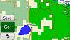
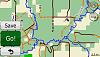
Been working on a Garmin trail map of the Great Lakes area the last few years and have uploaded it to GPSFile for free. The map contains Michigan DNR Jeep Routes, Drummond Island and Appleton OHV trails, National Forest roads, and a few state roads and seasonal roads (MI) in the Great Lake states (MI, MN, WI, IL, IN & OH). MI DNR routes are one color, US forest roads another and so are state trails. Drummond Island trails are color coded by difficulty like the paper map. Dead end trails are color coded the same except they are broken lines. Many non-dead end trails have starting points searchable under POI-Attractions-Landmarks using keyword "Trail". All starting/ends points start with "Trail" for easy searching. The map is routable and many times take you via trails seeing I made them principle highway category. Also includes many off-road parks locations.
Some roads/trails may be closed so use your best judgement when riding.
The map is finished as far as I can make it. If anyone has gpx files of legal trails in their area that can be added PM me. Many trails are hand drawn using Google Earth and may be off by a few yards, but generally accurate.
The file is located at:
Great Lakes Offroad Map Garmin Compatible Map - GPSFileDepot
 ---
---  ---
--- 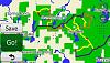
DNR Jeep Trails ---- US Forest (orange) State (brown) -- Drummond Island
Some roads/trails may be closed so use your best judgement when riding.
The map is finished as far as I can make it. If anyone has gpx files of legal trails in their area that can be added PM me. Many trails are hand drawn using Google Earth and may be off by a few yards, but generally accurate.
The file is located at:
Great Lakes Offroad Map Garmin Compatible Map - GPSFileDepot
DNR Jeep Trails ---- US Forest (orange) State (brown) -- Drummond Island

The following users liked this post:
GL08JK (06-11-2018)
12-08-2012, 08:27 AM
#3
JK Enthusiast
Join Date: Oct 2010
Location: Zeeland, Michigan, United States
Posts: 239
Likes: 0
Received 1 Like
on
1 Post
Looks great.
I do have some gps tracks in the Gun Lake/Barry State Game Area I can give you sometime. There's a few trails up in the hills that are nice.
I saw you got the ones North of Sweeter road by Twin Lakes. That's one of my favorite close to home spots.
Thanks for sharing your hard work!
I do have some gps tracks in the Gun Lake/Barry State Game Area I can give you sometime. There's a few trails up in the hills that are nice.
I saw you got the ones North of Sweeter road by Twin Lakes. That's one of my favorite close to home spots.
Thanks for sharing your hard work!
 05-30-2018, 08:41 PM
#5
JK Newbie

Join Date: May 2018
Location: Dunlap
Posts: 1
Likes: 0
Received 0 Likes
on
0 Posts
Been working on a Garmin trail map of the Great Lakes area the last few years and have uploaded it to GPSFile for free. The map contains Michigan DNR Jeep Routes, Drummond Island and Appleton OHV trails, National Forest roads, and a few state roads and seasonal roads (MI) in the Great Lake states (MI, MN, WI, IL, IN & OH). MI DNR routes are one color, US forest roads another and so are state trails. Drummond Island trails are color coded by difficulty like the paper map. Dead end trails are color coded the same except they are broken lines. Many non-dead end trails have starting points searchable under POI-Attractions-Landmarks using keyword "Trail". All starting/ends points start with "Trail" for easy searching. The map is routable and many times take you via trails seeing I made them principle highway category. Also includes many off-road parks locations.
Some roads/trails may be closed so use your best judgement when riding.
The map is finished as far as I can make it. If anyone has gpx files of legal trails in their area that can be added PM me. Many trails are hand drawn using Google Earth and may be off by a few yards, but generally accurate.
The file is located at:
Great Lakes Offroad Map Garmin Compatible Map - GPSFileDepot
Attachment 395893 --- Attachment 395894 --- Attachment 395895
DNR Jeep Trails ---- US Forest (orange) State (brown) -- Drummond Island