Off road GPS
 03-19-2012, 09:59 AM
#1
JK Newbie
Thread Starter
Join Date: Oct 2011
Location: Fresno, CA
Posts: 36
Likes: 0
Received 0 Likes
on
0 Posts
What kind of GPS apps are are you guys using for off road terrain. I'm having a hard time finding a topographic app that is gps enabled without using a cell phone signal for my iPad/iPhone for when I'm off road. Are any of you running apps like this? I would imagine maps would be downloadable to soley use a gps signal.
 03-19-2012, 10:51 AM
#2
JK Enthusiast
Join Date: Nov 2009
Location: Christchurch, New Zealand
Posts: 325
Likes: 0
Received 0 Likes
on
0 Posts
Check out MotionX GPS. You can download maps ahead of time to whatever level of detail you like. Not great maps but good for the very low cost of the app.
03-21-2012, 11:07 AM
#3
JK Enthusiast
Another app to check out is EveryTrail Pro. Not only will it cache maps for offline use, you can download trail eguides by FunTreks (they're better known for their printed trail guides). EveryTrail used to charge for those e-guides, but are now letting you download them for free.
I've got the Android version, but I hear that the iPhone one works just as well.

I've got the Android version, but I hear that the iPhone one works just as well.
03-26-2012, 12:03 PM
#5
JK Freak
I use a garmin nuvi with downloaded garmin 24k topo maps on an sdhc card for mine when off road. totally separate from my 2012 JK in-dash nav. I had the unit in my 2006 LJR before I bought the 2012. works great. I have a 3790T and a 1490T, both work fine, the 3790T is better.
03-27-2012, 07:26 AM
#6
JK Newbie

Join Date: Mar 2010
Location: Ramona, Ca.
Posts: 83
Likes: 0
Received 0 Likes
on
0 Posts
Using a Lowrance Baja 5s, I love this unit same one SCORE is using in baja. Only drawback is that map create software is no longer avilabe. SometimeS hard to find lowrance compatable maps to upload.
04-01-2012, 08:50 PM
#7
JK Freak
This is maybe one step further than you want, but I always take my laptop that has National Geographic State series topo maps (California, in my case), and I link it to my hand-held Garmin e-Trex GPS with a USB cable. The advantage is that unlike your in-dash unit, you'll know exactly where you are or where landmarks are relative to you because it has full topo map detail. This complements the in-dash unit when you're on a 4WD trail or otherwise off a paved road, especially at night, and you're not quite clear where you are. And 15" of map on the screen beats the 4" in the dash.
Trending Topics
04-02-2012, 12:09 PM
#8
JK Newbie

Join Date: Nov 2010
Location: Tucson, Arizona
Posts: 49
Likes: 0
Received 0 Likes
on
0 Posts
Garmin has some nice software topo maps that can be down loaded to your GPS (Garmin). I have used a Garmin Etrex Vista for a while now and had a garmin 12 before that, it's nice to be able to down load your saved way points onto your computer and always have them, using the laptop with it is a good idea if you can carry it along safely. I've been looking at the new Montana 650, but it is a little pricey.
You can keep your tracks also to follow again later.
You can keep your tracks also to follow again later.
04-04-2012, 09:35 PM
#9
JK Super Freak
Join Date: Mar 2011
Location: Seattle, WA
Posts: 1,934
Likes: 0
Received 0 Likes
on
0 Posts
I use OruxMaps on my Acer A100.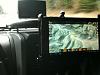
I attached mine to my Vector e-dock using a RAM mount. I placed it in front of the radio because I also use it for music playing and other apps.
The A100 runs Honeycomb but you may want to check the Apple store to see if they also have for iOS.
OruxMaps can download Google Topo Maps for off-network use. Works great.
Only thing is that the maps can take a lot of memory space if you download the full resolution. The A100 allows for storing stuff on external memory cards, so not an issue for me.
04-07-2012, 10:20 AM
#10
JK Enthusiast

Join Date: Mar 2007
Location: Mount Dora, FL
Posts: 278
Likes: 0
Received 0 Likes
on
0 Posts
I use OruxMaps on my Acer A100.Attachment 299844
I attached mine to my Vector e-dock using a RAM mount. I placed it in front of the radio because I also use it for music playing and other apps.
The A100 runs Honeycomb but you may want to check the Apple store to see if they also have for iOS.
OruxMaps can download Google Topo Maps for off-network use. Works great.
Only thing is that the maps can take a lot of memory space if you download the full resolution. The A100 allows for storing stuff on external memory cards, so not an issue for me.

