SoCal 4x4 Trails and Waypoints!
#1
JK Jedi
Thread Starter
We have started a small database of GPS waypoints marking different trailheads, campsites and other off-road points of interest in Southern California.  Our Local Area Leaders will be updating this file on a regular basis as new waypoints are visited.
Please help us contribute to this database!
The database is small right now, but we can make it bigger with your help. The next time you visit a SoCal trail, campsite or other off-road POI, we encourage you to mark it on your GPS and post in this thread! Feel free to give us as much information about the waypoint as you like, including pictures or non-commercial links. Just make sure that your coordinates are in the WGS84 format (see example below) and only share waypoints that you have actually visited and marked yourself. Also, please only use this thread for posting waypoints, POIs and trail information-- there is a discussion thread on this topic here, for suggestions, comments or questions.
The file can be downloaded below in the GPS eXchange file format (GPX)-- it can be opened in most GPS/mapping programs including Garmin Mapsource, Magellan Mapsend, National Geographic Topo! and Google Earth.
NOTE: These waypoints are to be used at your own risk and their accuracy is not guaranteed. Just because a waypoint is listed does not mean it is always accessible to vehicle travel. Know before you go and always tread lightly! Please report any errors to an Area Leader.
Latest file version is SoCal4x4-v1-1.gpx, as of 1/30/08. Click below for download.
 Our Local Area Leaders will be updating this file on a regular basis as new waypoints are visited.
Please help us contribute to this database!
The database is small right now, but we can make it bigger with your help. The next time you visit a SoCal trail, campsite or other off-road POI, we encourage you to mark it on your GPS and post in this thread! Feel free to give us as much information about the waypoint as you like, including pictures or non-commercial links. Just make sure that your coordinates are in the WGS84 format (see example below) and only share waypoints that you have actually visited and marked yourself. Also, please only use this thread for posting waypoints, POIs and trail information-- there is a discussion thread on this topic here, for suggestions, comments or questions.
The file can be downloaded below in the GPS eXchange file format (GPX)-- it can be opened in most GPS/mapping programs including Garmin Mapsource, Magellan Mapsend, National Geographic Topo! and Google Earth.
NOTE: These waypoints are to be used at your own risk and their accuracy is not guaranteed. Just because a waypoint is listed does not mean it is always accessible to vehicle travel. Know before you go and always tread lightly! Please report any errors to an Area Leader.
Latest file version is SoCal4x4-v1-1.gpx, as of 1/30/08. Click below for download.
Last edited by doojer; 01-31-2008 at 02:09 PM. Reason: file update
#2
JK Jedi
Thread Starter
N33 20.044, W116 22.064 - South Coyote Canyon Trailhead
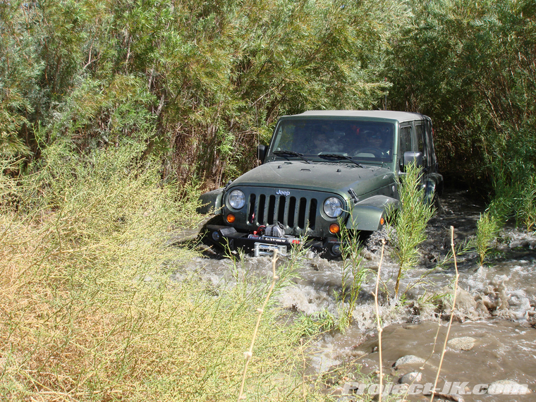
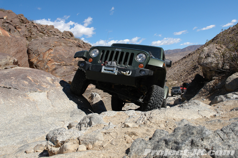
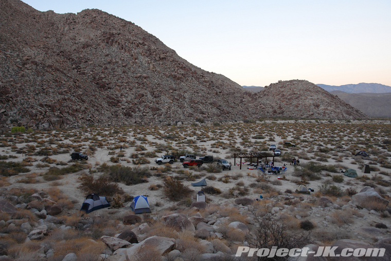
Located in Anza-Borrego Desert State Park, just outside of Borrego Springs, CA. The trail is moderate with 3 river crossings (one can be fairly deep) and a couple of fun, rocky hill climbs. There is a designated campground, Sheep Camp, at the end of the trail that has a couple pavillions and can accomodate a lot of Jeeps. Here are a couple of pics:
River crossing:

Hill Climb:

Sheep Camp:

Located in Anza-Borrego Desert State Park, just outside of Borrego Springs, CA. The trail is moderate with 3 river crossings (one can be fairly deep) and a couple of fun, rocky hill climbs. There is a designated campground, Sheep Camp, at the end of the trail that has a couple pavillions and can accomodate a lot of Jeeps. Here are a couple of pics:
River crossing:
Hill Climb:
Sheep Camp:
The following users liked this post:
Blanco562 (02-21-2018)
#3
JeepSWAG
Sponsoring Manufacturer
Sponsoring Manufacturer
Orange County Trail Heads:
Bedford Road Coordinates: 33.796602° -117.530445° Road to Main Divide from South East Corona
Blackstar Canyon Coordinates: 33.775797° -117.676251° Road that goes to Beeks Place, from Santiago Canyon Road
Maple Springs Road Coordinates: 33.750854° -117.580272° Road to Main Divide from Santiago Canyon
Skyline Drive (Cleveland National Forest) Coordinates: 33.836268° -117.609932° Road from North West Corona to Main Divide, close to Beeks Place
Main Divide Road Coordinates: 33.653192° -117.411739° Main Divide Road Entrance at Ortega Hwy (Hwy 74)
Trabuco Creek Road Coordinates: 33.660434° -117.584698° Better known as Trabuco Canyon, or the road to Holy Jim Trail.
#4
JK Enthusiast
Join Date: Apr 2008
Location: Rancho Cucamonga
Posts: 337
Likes: 0
Received 0 Likes
on
0 Posts
Sugarpine Mountain Trail
N34 12.52 W117 20.96
This is a 17 mile easy trail along a shelf road in the San Bernardino National Forest right off the I215 3 miles south of I15. This trail offers beautiful views and a great fragrance of fresh pine. The end of the trail gets rocky so watch your tires.
N34 12.52 W117 20.96
This is a 17 mile easy trail along a shelf road in the San Bernardino National Forest right off the I215 3 miles south of I15. This trail offers beautiful views and a great fragrance of fresh pine. The end of the trail gets rocky so watch your tires.
#5
JK Freak
Does anyone have a good definition of WGS84 data. I see DD.dd, DD MM.mm, DD MM SS.ss representations. Are all of these valid?
More importantly I guess... Are we all going to post in the decimal form, or the degree, minute, second form.
Btw, found a good decimal to DegMinSec converter at: http://www.fcc.gov/mb/audio/bickel/DDDMMSS-decimal.html
More importantly I guess... Are we all going to post in the decimal form, or the degree, minute, second form.
Btw, found a good decimal to DegMinSec converter at: http://www.fcc.gov/mb/audio/bickel/DDDMMSS-decimal.html
#6
#7
Jeepers Jamboree offered this info
Looks like it's all WGS-84 data google earth, I know it's not SO-CAL
Have fun
33

38.90682842, -120.83852748, Georgetown - The Official Beginning Of The Trail And Home Of Jeepers Jamboree Offices, Ru001
38.76945441, -120.44745524, Turnoff Hwy 50 - Alternate Route To Trail., Ru001A
38.92464856, -120.78922432, Obtain Permits At The Georgetown Ranger Station, Ru002
38.81452413, -120.37432974, Ice House - Country Store, Ru002A
38.92933253, -120.48518485, Uncle Toms Cabin - Country Store., Ru005
38.95269867, -120.38420669, Turnoff To Loon Lake, Ru007A
39.01207132, -120.40711093, Turnoff To Wentworth Springs, Ru008
39.01698061, -120.38443373, Laywer Cow Camp, Ru009
39.01296776, -120.38378477, Gerle Meadow, Ru009B
39.01407429, -120.35878167, Neck Meadow, Ru010
39.00683250, -120.35740263, Red Mountain, Ru010B
39.01296776, -120.34018708, Wentworth Springs, Ru011
38.98030000, -120.31958800, Loon Lake Campground, Ru011A
39.03127934, -120.33157030, Jerrett Peak, Ru011B
39.02240074, -120.32490040, Bugle Lake, Ru011C
39.00407286, -120.31182200, Loon Lake Staging Area, Ru012A
39.02167948, -120.30693675, Ellis Creek - Junction Of Trails From Wentworth Springs, Mckinstry Lake And Loon Lake., Ru014
39.02242175, -120.29057748, Walker's Rock, Ru015
39.02877972, -120.29128052, Devils Peak, Ru015B
39.01933359, -120.28406982, Mud Lakes, Ru016
39.01352103, -120.27490322, Spider Lake, Ru017
39.01985179, -120.27323575, Little Sluice Box, Ru018
39.00797415, -120.26406915, Old Sluice Box, Ru021
39.00543168, -120.25647087, Buck Island Dam - "Mechanics Area, Ru023
39.00627217, -120.24428479, Big Sluice Box, Ru025
39.01255456, -120.24493375, Rubicon River Bridge, Ru025
39.00823329, -120.25072935, Fawn Lake, Ru025B
39.01768091, -120.24573594, Rubicon Springs, Ru028
39.03083124, -120.25105384, Cadillac Hill, Ru030
39.03377887, -120.25933713, Fern Lake, Ru030B
39.03510212, -120.25375785, Observation Point, Ru033
39.03239959, -120.24138249, Dollar Hole, Ru034
39.03347081, -120.23327045, Pacific Crest Trail, Ru035
39.02573385, -120.21907439, Sourdough Hill, Ru035B
39.03461903, -120.19988492, Miller Lake, Ru035C
39.03407293, -120.21683006, Miller Meadows, Ru035C
39.02296794, -120.21183665, Richardson Lake, Ru035E
39.03797256, -120.18962770, Lily Lake, Ru036
39.04217301, -120.17782919, Mckinney Lake, Ru037
39.04600820, -120.16752691, Rubicon Trail Staging Area, Ru038
Looks like it's all WGS-84 data google earth, I know it's not SO-CAL
Have fun
33

38.90682842, -120.83852748, Georgetown - The Official Beginning Of The Trail And Home Of Jeepers Jamboree Offices, Ru001
38.76945441, -120.44745524, Turnoff Hwy 50 - Alternate Route To Trail., Ru001A
38.92464856, -120.78922432, Obtain Permits At The Georgetown Ranger Station, Ru002
38.81452413, -120.37432974, Ice House - Country Store, Ru002A
38.92933253, -120.48518485, Uncle Toms Cabin - Country Store., Ru005
38.95269867, -120.38420669, Turnoff To Loon Lake, Ru007A
39.01207132, -120.40711093, Turnoff To Wentworth Springs, Ru008
39.01698061, -120.38443373, Laywer Cow Camp, Ru009
39.01296776, -120.38378477, Gerle Meadow, Ru009B
39.01407429, -120.35878167, Neck Meadow, Ru010
39.00683250, -120.35740263, Red Mountain, Ru010B
39.01296776, -120.34018708, Wentworth Springs, Ru011
38.98030000, -120.31958800, Loon Lake Campground, Ru011A
39.03127934, -120.33157030, Jerrett Peak, Ru011B
39.02240074, -120.32490040, Bugle Lake, Ru011C
39.00407286, -120.31182200, Loon Lake Staging Area, Ru012A
39.02167948, -120.30693675, Ellis Creek - Junction Of Trails From Wentworth Springs, Mckinstry Lake And Loon Lake., Ru014
39.02242175, -120.29057748, Walker's Rock, Ru015
39.02877972, -120.29128052, Devils Peak, Ru015B
39.01933359, -120.28406982, Mud Lakes, Ru016
39.01352103, -120.27490322, Spider Lake, Ru017
39.01985179, -120.27323575, Little Sluice Box, Ru018
39.00797415, -120.26406915, Old Sluice Box, Ru021
39.00543168, -120.25647087, Buck Island Dam - "Mechanics Area, Ru023
39.00627217, -120.24428479, Big Sluice Box, Ru025
39.01255456, -120.24493375, Rubicon River Bridge, Ru025
39.00823329, -120.25072935, Fawn Lake, Ru025B
39.01768091, -120.24573594, Rubicon Springs, Ru028
39.03083124, -120.25105384, Cadillac Hill, Ru030
39.03377887, -120.25933713, Fern Lake, Ru030B
39.03510212, -120.25375785, Observation Point, Ru033
39.03239959, -120.24138249, Dollar Hole, Ru034
39.03347081, -120.23327045, Pacific Crest Trail, Ru035
39.02573385, -120.21907439, Sourdough Hill, Ru035B
39.03461903, -120.19988492, Miller Lake, Ru035C
39.03407293, -120.21683006, Miller Meadows, Ru035C
39.02296794, -120.21183665, Richardson Lake, Ru035E
39.03797256, -120.18962770, Lily Lake, Ru036
39.04217301, -120.17782919, Mckinney Lake, Ru037
39.04600820, -120.16752691, Rubicon Trail Staging Area, Ru038
Last edited by 33 williys 77; 04-27-2008 at 11:54 AM.
Trending Topics
#8
Mojave and Government Rd would be cool todo with a Jeep Trailer
Here are some waypoints around the old road
WGS-84 datum
plug'em into Google earth
35.03917908 -116.38252305 Afton Canyon Campground
35.03640424 -116.37974693 Afton Station
35.05077928 -114.63696615 Aha Macav Parkway
35.16383908 -115.78574761 Aiken Cinder Mine Road
35.01578919 -114.64180633 Avi
35.26539469 -116.07497774 Baker
35.10256897 -114.77508708 Balancing Rock Camp
35.12891222 -115.33388918 Barnett Mine
34.88691064 -117.00756443 Barstow
35.17763176 -115.60438051 Beale Mountins
35.17284290 -115.74436721 Benchmark
35.15414154 -115.33382609 Bert G. Smith Homestead
35.17433853 -115.41155742 Black Canyon Road
35.19242387 -115.89208739 Branningan Mine
35.11457305 -115.09409740 Cable Road
35.00261883 -116.39122096 Cady Mountains
34.94611872 -116.58947010 Camp Cady Site
35.13982893 -115.25565310 Carruthers Canyon Road
35.23681350 -115.30138696 Caruthers Canyon
35.07111993 -116.32417949 Cave Mountain
35.14557049 -115.30891313 Cedar Canyon Road
35.15602072 -115.32966191 Cedar Canyon Road
35.15290348 -115.36200189 Cedar Canyon Road
35.23779262 -115.49916741 Cima
35.28890423 -115.58461419 Cima Dome
35.18039444 -115.81692487 Cima Volcanic Field
35.52542119 -115.58878738 Clark Mountain
34.98186972 -116.51106277 Cliffs
35.04627813 -114.62788968 Colorado River
35.13528847 -115.99417285 Cowhole Mountain
35.04409387 -116.30340366 Cross Road
35.15949154 -116.02174476 Crossroad
35.04723003 -116.16557116 Crucero
35.00003471 -114.75081407 Dead Mountains
35.16386855 -115.45582210 Death Valley Mind Road
35.12243963 -115.12931265 Detour
35.23085015 -115.32054939 Drum Peak
35.04500891 -116.43779306 Dunn Siding
35.15280030 -115.15110699 Eagle Mountain
35.00140061 -116.51780477 Field Siding
35.06613300 -115.26304407 Ford Lake
35.11497857 -114.77398745 Forks Of The Road
35.04367325 -114.62182368 Fort Mojave
35.11502280 -114.98526092 Fort Piute
34.91914004 -115.06245145 Goffs
35.13113843 -115.17647963 Goffs Vortac Station
35.14749408 -115.35920775 Government Holes
35.16389066 -115.99902205 Graded Road
34.79307783 -115.71026962 Granite Mountains
35.16280748 -116.03025339 Green Rock Mill
35.16058213 -115.21526418 Grotto Hills
35.13956359 -115.22066319 Grotto Hills
35.05113346 -115.22276330 Hackberry Mountain
35.18537438 -115.67001590 Highpoint
35.16710327 -115.38493192 Highpoint
35.11163856 -115.01021895 Hiking Trail
35.04334856 -115.39582908 Hole-In-The-Wall Campground
35.14352893 -115.15426167 Indian Hill
35.14526832 -115.15829065 Indian Well
35.18865243 -115.58995912 Intersection
35.18873346 -115.60035154 Intersection
35.18482926 -115.84984171 Intersection
35.00018976 -116.47153913 Intersection
35.10722924 -115.05292431 Intersection
35.12636895 -115.12927660 Intersection
35.09995114 -115.01382430 Intersection
35.11963813 -115.11840647 Intersection
35.16887162 -115.82155774 Intersection
35.07685158 -114.71478761 Intersection
35.13867173 -115.18692613 Ivanpah-Goffs Road
35.54503900 -115.53538900 Ivanpath
35.07502222 -115.85834132 Jackass Canyon
35.18674455 -115.95398222 Jackass Canyon Road
35.14334467 -115.29146323 Joshua Tree Forest
35.13154386 -115.16514982 Junction
35.20028293 -115.87228501 Kelbaker Road
35.01251895 -115.65361156 Kelso
35.17620987 -115.50901001 Kelso Cima Road
34.91084735 -115.73111755 Kelso Dunes
35.10474429 -115.72501550 Kelso Mountains
35.17723393 -115.51604044 Kelso Wash
35.12666383 -115.18342894 Lanfair
35.14728035 -115.15369382 Lanfair Buttes
35.09259864 -114.73784382 Leave Wash
35.17779384 -116.00862129 Little Cowhole Mountain
34.97438103 -116.54080690 Manix Wash
35.16030212 -115.67361223 Marl Mountains
35.17069887 -115.64759063 Marl Springs
35.13169129 -115.43555102 Mid Hills Campground
35.03100187 -116.36674965 Middle Railroad Bridge
34.94325206 -115.51295787 Mitchell Caverns State Park
35.04570255 -116.29295716 Mojave River
35.03774001 -116.38112598 Mojave River
35.12659011 -115.14595134 Mojave Road
35.14741301 -115.31494307 Mojave Road
35.15641128 -115.33524119 Mojave Road
35.18540385 -115.69284677 Mojave Road Mail Box
35.16921792 -115.98314048
35.11211782 -114.95420985 Mwd Power Line
35.15240972 -116.05271471 Narrow Channel
34.84809293 -114.61413528 Needles
35.05079404 -114.67714777 Needles Highway
35.32279893 -115.21054117 New York Mountains
35.10113102 -115.86251451 Old Dad Mountain
35.19794812 -115.89121309 Oro Fino Mine
35.19984101 -115.90154242 Paymaster Mine
35.20789819 -115.92033530 Paymaster Mine Road
35.18001872 -115.37305229 Pinto Mountain
35.10394054 -115.01249032 Piute Corral
35.09992902 -115.00596464 Piute Range
35.15349304 -115.33764776 Pleasant View School
35.06028992 -114.70144782 Pole Line
35.09689075 -114.74102554 Power Line
35.03030072 -115.52805527 Providence Mountains
35.06628054 -114.70640518 Quarry
35.04086904 -116.39467308 Railroad Bridge
35.20473139 -115.65166467 Rainbow Wells
35.09478160 -115.01952075 Range Fence
35.09057050 -116.12918417 Rasor Ranch
35.10877769 -116.14363261 Rasor Road
35.15282978 -115.32730041 Rock Spring Canyon
35.15383203 -115.34355152 Rock Spring Wash
35.10573238 -115.04912067 Sacramento Wash
35.10391104 -114.75546497 Service Road
35.08947897 -114.98443169 Service Structure
35.22177176 -115.89279944 Seventeenmile Point
35.09357950 -116.17790145 Shaw Pass
35.02616749 -116.44974479 Structures
35.20806758 -115.91945199 Tank Nine
35.17556890 -115.77528308 Tank Six
35.09116051 -114.95505711 Telephone Cable Road
35.30007899 -115.56382033 Teutonia Peak
35.02809389 -116.37190530 The Caves
35.11856910 -116.11186047 The Granites
35.12061866 -116.11544779 Tonopah And Tidewater Railroad
35.13084357 -116.09527586 Travelers Mounument
34.99169113 -116.48540169 Triangles
35.11288463 -114.82925746 U.S. Highway 95
35.04272130 -116.30950572 Union Pacific Railroad Bridge
35.07283136 -114.71896081 Wash
35.00966937 -116.46541003 Water Tank
35.14881330 -115.32159494 Watson Wash
35.16285169 -115.44209473 Willow Wash
35.14279189 -116.10473990 Zzyzx
33

Last edited by 33 williys 77; 12-09-2011 at 02:06 PM.
#9
Hi,
Here's some Baja interested places.
Should you need some Xtreme tracks from Baja, please send e-mail and I'll sent on any chance.
Geranuno@yahoo.com
Here's these to start-up
Here's some Baja interested places.
Should you need some Xtreme tracks from Baja, please send e-mail and I'll sent on any chance.
Geranuno@yahoo.com
Here's these to start-up

