
Winter At Green Ridge


Thread Starter
JK Enthusiast
Joined: Mar 2008
Posts: 363
Likes: 0
From: Baltimore, MD
I am watching this thread and kind of interested in going if things work out - and you all don't mind a TJL Rubicon coming along. I have not been there in a year or so but was given the following from Atomicha regarding stream crossings:
Green ridge river crossings
Here are the the directions in google maps.
http://maps.google.com/maps?f=d&hl=e...49689&t=h&z=13
point A is where you'd turn off the road that comes out of the ATV trail. Normaly you'd go north on that road to head back to Flintstone, but for the rivers you'd want to head south. point B is just after where the 3rd river crossing is. as you can see in the map, the road will take you back to Flintstone after it ends on Town Creek Rd.
Dave
Jarrettsville
dp, I certainly don't mind if you tag along in your LJ. Just be prepared, as they say, "En caso de fuego...." Since I don't know anyone, I'll just say that I have a stock Sahara, not a Rubicon, and I have stock Duelers and not IMAXUS super snow bogger '37's, so I will be exercising due caution on an isolated trail I've never driven in the snow--even though in dry weather, you could do it in a Mini
 I guess that's my advice and disclaimer. All pertinent information I have listed in the rest of this thread. Looking forward to meeting some folks, taking some good pics, having some beer, and lots 'o fun!! Most of all, I'm looking forward to just getting out in my jeep!!

JK Super Freak
Joined: May 2007
Posts: 1,766
Likes: 2
From: Martinsburg, WV
I've been asked to jump in and give some info on the greenridge area, more specifically about the crossings.
so here goes...
there are 3 crossings, one of which is like this...
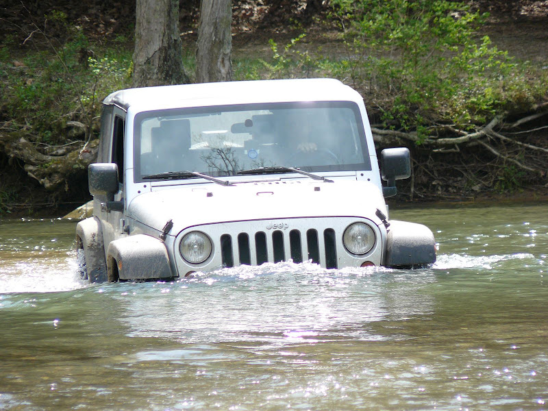
... near the green ridge area.
here's the aproximite location of each, (google link to the lat, lon of each) which you can use to either get directions to, or pinpoint on your own gps tracker.
#1 - ((39.570156�, -78.540425�)) --> http://maps.google.com/maps?f=q&sour...=UTF8&t=h&z=17
#2 - ((39.590709�, -78.548651�)) --> http://maps.google.com/maps?f=q&sour...=UTF8&t=h&z=17
#3 - ((39.599286�, -78.555255�)) --> http://maps.google.com/maps?f=q&sour...=UTF8&t=h&z=17
Those are in the order you'll come to them when leaving the Greenridge area. You'll want to turn onto the road that is here: http://maps.google.com/maps?f=q&sour...=UTF8&t=h&z=15 which is "Pack Horse Rd SE". follow that road a bit and it'll you hit the river.
Now, do keep in mind, these are public roads, they have people living on them, there are speed limits, there are kids, etc. Don't go screaming through there and respect the people that live on the road.
Also, the river levels will vary during the year. I've seen it higher than the picture above, and i've seen it to where you wont even get your wheels wet because its lower than the rocks are.
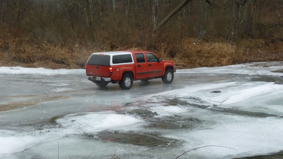
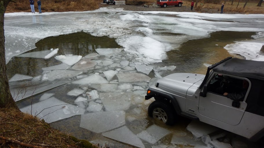
also, given the current time of the year, be very careful of the ice. a bunch of us went there over new years weekend and the river was frozen so well that for a while it could hold a truck up. but the ice broke and we had a lot of problems because of the thickness of the ice. obviously you wont have to worry about that during the summer.
This is the ice encounted...
and lastly, i have a custom GPX/KML file that i've made from all my trips to the area over the years with details about the various off road trails, POI, etc. Just shoot me an email and i can send it to you.
so here goes...
there are 3 crossings, one of which is like this...
... near the green ridge area.
here's the aproximite location of each, (google link to the lat, lon of each) which you can use to either get directions to, or pinpoint on your own gps tracker.
#1 - ((39.570156�, -78.540425�)) --> http://maps.google.com/maps?f=q&sour...=UTF8&t=h&z=17
#2 - ((39.590709�, -78.548651�)) --> http://maps.google.com/maps?f=q&sour...=UTF8&t=h&z=17
#3 - ((39.599286�, -78.555255�)) --> http://maps.google.com/maps?f=q&sour...=UTF8&t=h&z=17
Those are in the order you'll come to them when leaving the Greenridge area. You'll want to turn onto the road that is here: http://maps.google.com/maps?f=q&sour...=UTF8&t=h&z=15 which is "Pack Horse Rd SE". follow that road a bit and it'll you hit the river.
Now, do keep in mind, these are public roads, they have people living on them, there are speed limits, there are kids, etc. Don't go screaming through there and respect the people that live on the road.
Also, the river levels will vary during the year. I've seen it higher than the picture above, and i've seen it to where you wont even get your wheels wet because its lower than the rocks are.
also, given the current time of the year, be very careful of the ice. a bunch of us went there over new years weekend and the river was frozen so well that for a while it could hold a truck up. but the ice broke and we had a lot of problems because of the thickness of the ice. obviously you wont have to worry about that during the summer.
This is the ice encounted...
and lastly, i have a custom GPX/KML file that i've made from all my trips to the area over the years with details about the various off road trails, POI, etc. Just shoot me an email and i can send it to you.

Thread Starter
JK Enthusiast
Joined: Mar 2008
Posts: 363
Likes: 0
From: Baltimore, MD
Can we get a count? It's kind of nice to know so no one gets left or ends up an unexpected surprise.
1. Vedo13
2. Initial E
3. Only1
Thread Starter
JK Enthusiast
Joined: Mar 2008
Posts: 363
Likes: 0
From: Baltimore, MD
There's a weigh station on Rt 70, just west of Rt 32, or if you're taking 83S to 695 to 70, you could just meet us at the terminal end of I70 (towards the City) at the park n'ride lot. It's at the bitter end of I70 before you fall off the highway into the trees and the Gwynns Falls, if you're not familiar. You can't miss the signs for it even though it doesn't show on Google maps.